Atlas

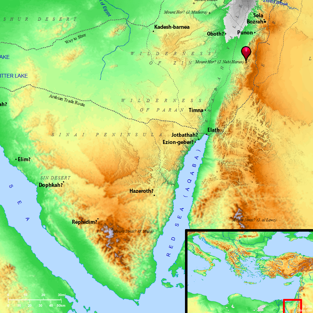
Mount Shepher (Mount Hor) and surrounding region
Maps Created using Biblemapper 3.0Additional data from OpenBible.info
You are free to use up to 50 Biblos coprighted maps (small or large) for your website or presentation. Please credit Biblos.com.
Occurrences
Numbers 33:23 They traveled from Kehelathah, and encamped in Mount Shepher.
Numbers 33:24 They traveled from Mount Shepher, and encamped in Haradah.
Encyclopedia
HOR, MOUNThor (hor ha-har; literally, "Hor, the mountain"):
1. Not Jebel Neby Harun:
(1) a tradition identifying this mountain with Jebel Neby Harun may be traced from the time of Josephus (Ant., IV, iv, 7) downward. Eusebius, Onomasticon (s.v. Hor) favors this identification, which has been accepted by many travelers and scholars. In HDB, while noting the fact that it has been questioned, Professor Hull devotes all the space at his disposal to a description of Jebel Neby Harun. It is now recognized, however, that this identification is impossible. Niebuhr (Reise nach Arabic, 238), Pocoke (Description of the East, I, 157), Robinson (BR, I, 185), Ewald (Hist. of Israel, II, 201, note), and others had pointed out difficulties in the way, but the careful discussion of Dr. H. Clay Trumbull (Kadesh Barnea, 127) finally disposed of the claims of Jebel Neby Harun.
2. Suggested Identification:
From Numbers 20:22; Numbers 33:37 we may perhaps infer that Mt. Hor, "in the edge of the land of Edom," was about a day's journey from Kadesh. The name "Hor the mountain" suggests a prominent feature of the landscape. Aaron was buried there (Numbers 20:28 Deuteronomy 32:50). It was therefore not in Mt. Seir (Deuteronomy 2:5), of which not even a foot-breadth was given to Israel. Jebel Neby Harun is certainly a prominent feature of the landscape, towering over the tumbled hills that form the western edges of the Edom plateau to a height of 4,800 ft. But it is much more than a day's journey from Kadesh, while it is well within the boundary of Mt. Seir. The king of Arad was alarmed at the march to Mt. Hor. Had Israel marched toward Jebel Neby Harun, away to the Southeast, it could have caused him no anxiety, as he dwelt in the north.
3. Jebel Maderah:
This points to some eminence to the North or Northeast of Kadesh. A hill meeting sufficiently all these conditions is Jebel Maderah (see HALAK, MOUNT), which rises to the Northeast of `Ain qadis (Kadeshbarnea). It stands at the extreme Northwest boundary of the land of Edom, yet not within that boundary. Above the barrenness of the surrounding plain this "large, singular-looking, isolated chalk hill" rises "alone like a lofty citadel," "steep-sided" and "quite naked." Here the solemn transactions described in Numbers 20:22 could have been carried out literally, "in the sight of all the congregation." While certainty is impossible, no more likely suggestion has been made.
(2) A mountain named only in Numbers 34:7 as on the North boundary of the land of Israel. No success has attended the various attempts made to identify this particular height. Some would make it Mt. Hermon (Hull, HDB, under the word); others Jebel Akkar, an outrunner on the Northeast of Lebanon (Furrer, ZDPV, VIII, 27), and others the mountain at the "knee of" Nahr el-Qasimiyeh (van Kasteren, Rev. Biblical, 1895, 30). In Ezekiel 47:15 ha-derekh, should certainly be amended to chadhrakh, a proper name, instead of "the way." Possibly then Mt. Hor should disappear from Numbers 34:7, and we should read, with slight emendation, "From the great sea ye shall draw a line for you as far as Hadrach, and from Hadrach."
W. Ewing


